Above and Beyond

MapTrack

Regional Bus Routes - Paratransit - Shuttle Buses - Municipal Street Restrictions

Public Map Tracking for your Customers

MapTrack allows close to realtime tracking of certain types of vehicles. The public can view the location and status of the vehicles. This important information is useful in situations like getting snowed in street updates and school buses dropping off young children at rural stops.The public only views maps and selected routes. They have no control over maps and displayed vehicles.

Use Cases

Gatlinburg Trolleys

The city of Gatlinburg, Tennessee needed an automatic system to display the location of all their trolley buses, and allow tourists to easily locate trolleys as well as the closest stop.

Datalink developed a bespoke solution that addressed those requirements. The Gatlinburg solution was based on Datalink’s MapTrack application. The system utilizes Kenwood’s NEXEDGE mobile radios using a cable connected to Datalink i50 MobiHUBs. The system uses the GPS location data to trigger an automated voice presentation of each tourist spot’s highlights.

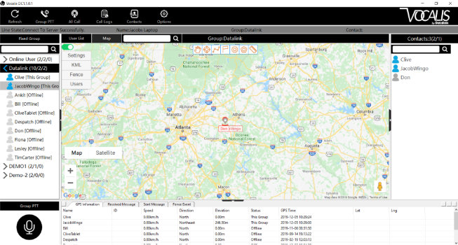
MapTrack includes a free to the public live map showing the location of each trolley and the next stop. This is a free download to Android smartphones. Click the button below to view the live Gatlinburg Trolley mapping site (COVID-19 restricted operation).
Liquid Cement
Liquid cement delivery is time critical. MapTrack allows work site crew and home base to observe the location of each truck in almost realtime.
Snow Plows

Let the public view what streets have been plowed in the past 30 minutes or more on their smartphones or tablets. The Meitrack T633L GPS unit can also report snowplow blade up/down as well as an optional interface to Dickey-John spreader control units in addition to other sensors.

School Buses
Parents and guardians can see the current location of every school bus. Optional RFID scanning can track the boarding and alighting of each student at each bus stop.
Snow plow tracking works a bit different from tracking of buses. Buses drive a predetermined route while snow plows may work different routes each time they plow. When a user looks at the public website to see the status of snow plowing they will see the current location of the snow plow as well as a breadcrumb trail showing where the plow has been. The most recently plowed areas will be displayed in green and change over a couple hour period to red to indicate the plow has been in that location. If you are already getting GPS data from your snowplows you can link the location data to MapTrack.

Devices

VOCX5
The VOCX5 is an industrial strength smartphone. With an IP68 rating it is water-resistant and dust-proof.
Meitrack T633L
The Meitrack T633L is a multi-port GPS black box. The T633L uses cellular data to send GPS information in addition to other data back to the server.
VOC100
Anysecu 4G-W2 Plus is a dash mounted mobile network radio with GPS mapping and text based messaging.

PTT Dispatch and Tracking

Vocalis DC is the command center for all dispatching within the Vocalis System. With the ability to track employees on a map, all call the entire company, and monitor groups, the dispatcher is in full control of all aspects of the Vocalis System. Easy to understand and quick to learn, you will be dispatching like a pro in no time.

Operational Choices

1. MapTrack can operate as a stand alone system with its own network agnostic SIM and cellular airtime with simple installation.
2. Linked to Datalink’s Vocalis Pro PoC server.
3. Linked to Datalink’s WebGate server with NEXEDGE – DMR system.